|
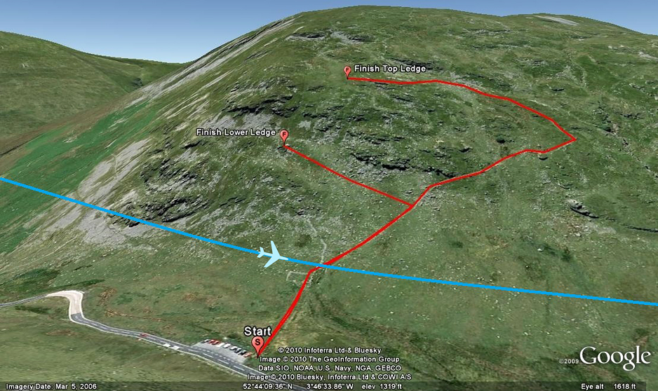
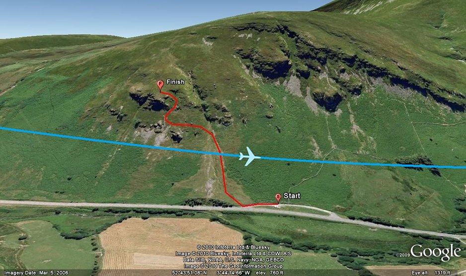
The Bwlch
is situated five miles east of Dolgellau on the A470
road to Dinas Mawddwy. The Bwlch was the first place I
used for shooting low level video. When looking down the
valley from the main viewing location you get a
fantastic view of the aircraft as they snake there way
through the twist and turns of this very narrow valley.
The aircraft usually come in from the east and can
either turn left towards the Cad pass, straight on for
Dolgellau or turn right and head up towards Bala.
Direction of flow
- Right to Left
Hillside faces
- North-East (Aircraft
pass from East to West)
Type of shot - Topside or level pass
Grid Ref : SH802167
Latitude : 52:44:06N
Longitude : 3:46:30W
Distance from Car park : Top Ledge 0.40
miles. Middle Ledge 0.29 miles.
Height Climbed : Top Ledge 423ft.
Middle Ledge 236ft.
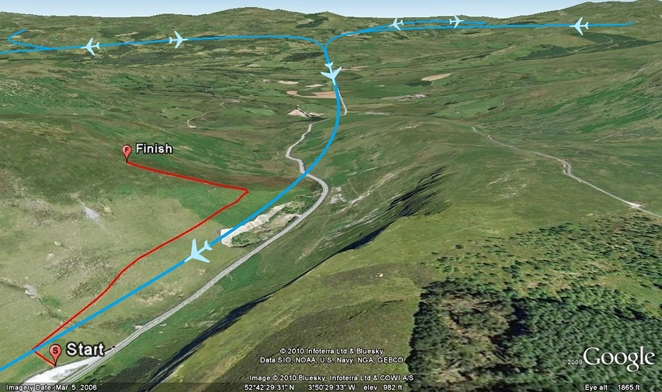
Cad West
or the 'Fence' as it is also know is a very popular
location. The stunning views combined with the
opportunity to spot incoming aircraft with plenty of
warning can make the 'Fence' almost irresistible to hill
climbers. There is enough parking for approx 20 cars and
a clearly marked path to the location. This location
offers a number of 'Entry' points into the Mach Loop
that pass via Cad West and onto Corris Corner.
Direction of flow - Left to Right
Hillside faces - South
Type of shot - Dramatic topside or
level pass
Grid Ref : SH754139
Latitude : 52:42:31N
Longitude : 3:50:42W
Distance from Car park : 0.40mile
Height Climbed : 307ft
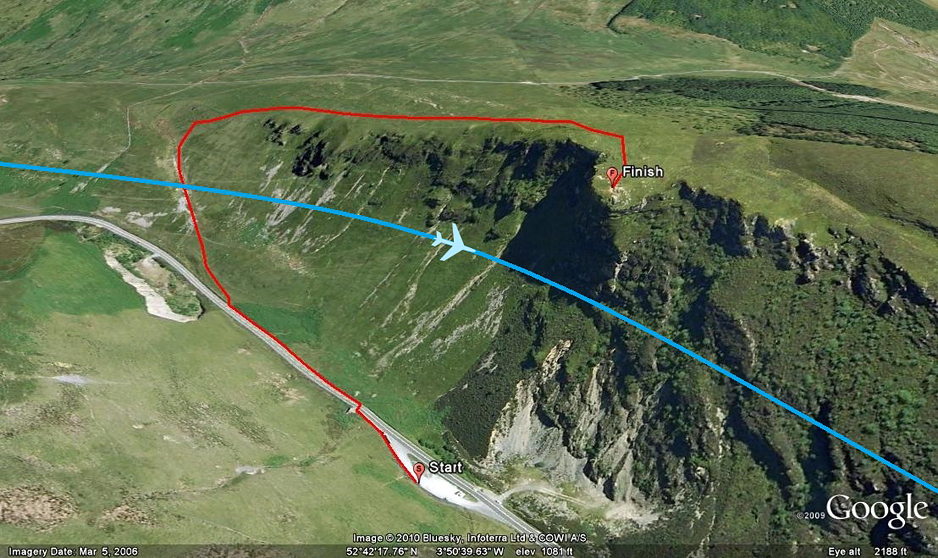
Cad East
sits in the shadow of
the massive Cadair Idris at the beginning of the Tal Y
Lyn valley. From the top its possible to see all the way
to Snowdon and towards Bala, so approaching aircraft can
be seen very early. The car parking is also very good as
it shares a large layby with Cad west. There is an
access road that runs up the back of Cad East which does
have very limited spaces for parking.
Direction of flow
- Right to Left
Hillside faces - North-West (Aircraft
pass from East to West)
Type of shot - Belly shots, head on,
level pass
Grid Ref : SH755133
Latitude : 52:42:13N
Longitude : 3:50:38W
Distance from Car park : 0.90mile
Height Climbed : 422ft
Corris Corner
is located at the south western end of the Tall-Y-llyn
pass, almost above the lake. From here the aircraft have
2 options, they can either go straight on over the lake
or turn sharp left and follow the valley to Corris
offering excellent topside views with the sun behind
you. Take note, this location could be tricky in the
afternoons due to the sun being in front of you
especially during the winter hours.
There's a few more locations in Wales, including
Heartbreak Hill which is located between the Bala and
Dolgellau valley, the A5 Pass which fly's over Lake
Ogwen, and the Dyfi Valley which is a new location north
east of Dinas village. Another location is BlueBell hill
which is located just east of the Bwlch.
Direction of flow - Right to Left
Hillside faces - North to South West
Type of shot - Topside
Grid Ref : SH734106
Latitude : 52:40:44N
Longitude : 3:52:26W
Distance from Carpark : 0.55mile
Height Climbed : 327ft
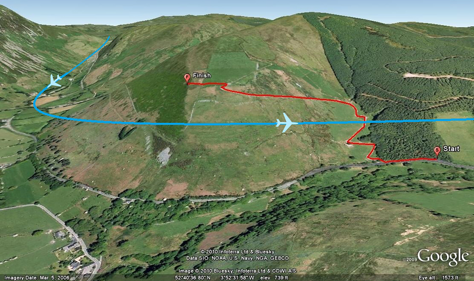
Bluebell
sits deep in the valley looking up towards the Bwlch
locations. There is a layby nearby to park in which has
a ample space. Aircraft approach from Dinas from the
right but give very little notice on their arrival.
Lighting can be tricky at times but when its good it
really can be the place to be.
Direction of flow - Right to Left
Hillside faces - North (Aircraft pass
from East to West)
Type of shot - Side on or dipped wings
Grid Ref : SH 8268916085
Latitude : 52°43'46.70"N
Longitude : 3°44'19.19"W
Distance from Car park : 0.22 miles
Height Climbed : 320ft
(Steep climb)
Please note that most of these locations are on
privately owned land so always make sure that care is
taken when crossing gates or fences and please do not
drop any litter.
Please check out Page 2 for information on aircraft that
use the Mach Loop on a regular basis.
|